Feb 19: Houtribdijk and bad decisions
The new bike is ready to ride! But it's got no pannier racks so the only way I can carry snacks and spare innertubes and all the rest of the stuff you bring on a trip is in a backpack. And that gives me back pain. And going for a 100km shakeout ride without bringing a bunch of gear is nearly as stupid as ... well, let's not be nasty about bad decisions today, and just say It's Obviously Inadvisable and I can make good decisions so I didn’t do it.
Happily, the old bike's now fixed. And I was very, very keen to do a long ride today, since last weekend's ride got cut short by the spoke problems. At least 140km: that's the daily average I'm aiming for, so I want to get in the habit of doing more than that distance.
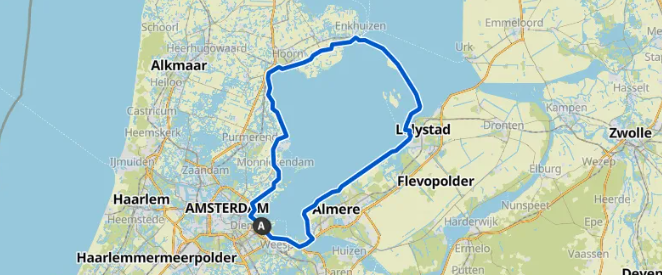
One nice route for this is over the Houtribdijk:
This is nearly exactly 100 miles which is a nice round number if you're American. I've cycled this route quite a few times over the years; I like it because it’s a nice scenic ride and you're next to the water almost the whole way. The Houtribdijk is a 30km dyke, which is pretty epic piece of civil engineering; it’s so long and so straight that you can’t see the end of the road - it vanishes into the haze. It lands at Lelystad, which has a tower so high you can probably see it from space. And then there’s Flevoland, which is 1400 sq km of reclaimed land, which is so big you can probably see from Mars.
On reflection, that's three pieces of civil engineering in a row. Let's move on before this gets weird.
I got out about 9. The weather was cloudy, no rain, a bit under ten degrees. In Scotland people sunbathe on days like this! But around here people prefer to stay indoors ...
From left to right: Durgerdam, just outside Amsterdam on the North - note that nobody is out and about. Some random countryside; note that even the ducks haven’t bothered to get up yet. And last is a cyclepath flanked by moats, which are undoubtedly there to stop non-cylists from getting access to our ways.
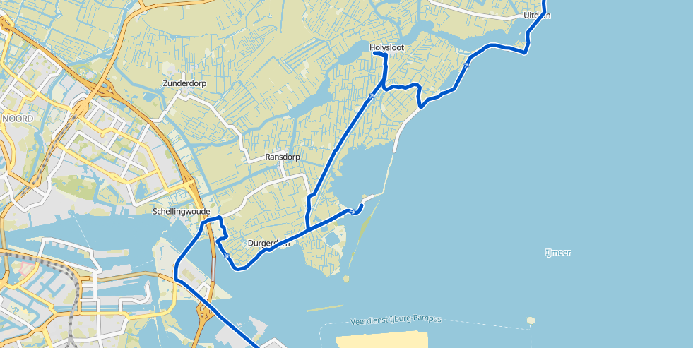
Here’s a GPS track of the first part of the ride, and there’s a few things to unpack. Firstly, it doesn’t really match the planned route at the top. That’s because Komoot likes to plan the fastest way to the destination, whereas I like the scenic way. So the planned route went due north with a vengeance, while I took the path of strict virtue along the lakeside.
Secondly, there’s some T-junctions. These are signs that all did not go well… after Durgerdam I hit a dead end; the road along the waterfront was completely closed and I needed to go back. Since I’d been following my normal lakeside route, rather than Komoot’s route the audio directions had been the increasingly tense message “updating route” alternating with suggestions I take a U-turn, or some thinly veiled ruse like “turn left”. Since the lakeside route had failed so badly I decided to follow Komoot’s route precisely, in the hope that knew a bit more about the closed roads than I did.
This plan came unstuck just under the word “Holysloot” on the map. That word covers the canal: and Komoot led me to a short ferry crossing there. At which there was no ferry - not even tied up, or out of the water: there was no ferry to be seen. I was so irked I didn’t stop to take a picture before retracing my route.
After that I figured that unthinking adherence to any one philosophy was evidently going to end badly, and that a more flexible and open minded approach was the right choice… in life as well as navigation in Waterland province. (See Aesop’s fable “The Bike & the Dyke” if you’d prefer a more subtle subtext.)
I’d spotted a possible route to the waterfront a bit earlier, so I backtracked and checked it out. It headed for a construction site but looked like there might be a route through - and to be honest if it was a kilometer of sand I’d take it, the other option was a canal crossing miles to the south. Fortunately the construction site was off to one side, and there was a very nice new asphalt road along the lakeside… I wish I’d got a photo of it because it’s so thematically consistent it’s not very believable.
From left to right: the deadend just after Durgerdam. Secondly the entrance to Holysloot. Not shown: no ferry.
After that it was a straightforward run to the start of the Houtribdijk, at Enkhuizen.
The Enkhuizen end of the dyke meets a big crossroads, and this is a spot I remember very, very well. One Sunday a few summers ago I rode this route anticlockwise, got over the dyke, got to this crossroad and looked at the road south… but I’d been itching to visit the Afsluitdijk (circled in the map in red), which is the outer dyke keeping out the North Sea. It’s got a statue of Dr. Cornelius Lely, civil engineer and politician, who was got the whole project planned, funded, and constructed. It’s also got a four-person village, apparently.
It was 1pm, the sun was out, and I remember checking the map, and having the thought: yeah, I can do that.
This was not a good thought. It wasn't just false and misleading, but dangerously wrong. I went took the Afsluitdijk route, got over to the east end around 5pm, turned south into a headwind … and realized I was in trouble. It’s about 140km from home from that point, at least 7 hours, I was already tired, and the headwind was serious. But I thought I could still finish it: so I pushed on south through lake country, doing my best… until it was 6pm.
Because at 6pm all the canal ferries stop. There’s lots of canals here, most just a few meters wide, and there are small ferries cross back and forth every few minutes. They’re ubiquitous. When they stop the whole region instantly switches from a nice network of interconnected bikepaths, into a complicated and sometimes unsolvable maze. It’s like nightfall in a dubious YA sci-fi novel.
My cellphone was near death, so I was trying not to use Google Maps, which meant navigating using cycle network mapboards and guesswork. I remember hitting a dead end when a route was crossed by a canal so thin the map didn’t show it. (Yes, I am still grumpy about that.) At about 10pm I got into Lemmer - after 5 hours, without the dead ends it would have taken half that time - thoroughly annoyed, well tired and with only enough cellphone battery to text my family letting them know that I was out overnight. I grumpily ate a massive pile of pasta at the last open restaurant, got a room at the last open hotel, and set an early alarm.
The next day was Monday and I was supposed to be at work so I rode out at 6am with intention of getting back before midday… but yesterday’s headwind had scaled up to gale force. There’s a big windfarm just south of Urk (https://www.google.nl/maps/@52.6049153,5.624031,297m/data=!3m1!1e3) and I have a vivid memory of all 28 of these wind turbines whirring like blenders while I was grinding slowly upwind.
Things went creatively wrong in a few more ways, I ended up getting home about 5pm, and nobody was pleased. The cost of bad decisions.
But it left some unfinished business. So on the summer solstice the year after I had a proper crack at the Afsluitdijk: left at 8am, went directly up the west side, over the dyke, back down the east side, to return at 3am in a single 19 hour, 290km ride.
That’s all basically folklore. It’s a long time since then; and today was the first time I’d gone over the Houtribdijk since it got closed for construction work in 2020.
From left to right: this is Navistad Krabbersgat, a canal over the approach road to the dyke. The concrete isn’t new and picturesque any more but it’s still impressive. After that is the view of the dyke cyclepath, though the camera had some creative differences about what to focus on (and I didn’t realize until now, oops). The last picture is the first view of the Lelystad tower at the end.
In the third picture you can see the bank on the right, it goes up to the road, and it’s is above head height. It hides the two islands in the middle on the south side: Trintelzand and Marker Wadden. They’re nature sanctuaries, intended as a nesting area for birds.
Lelystad is on the other side; it is named after Dr. Cornelius Lely. The weather was still cold, with heavy clouds and little sun. So I stopped in a Lelystad cafe for a toastie, for a drink to the good Dr - and to thaw out. 2.5 hours left.
The run from Lelystad is down a road so extraordinarily long and straight you could probably land the space shuttle on it. It’s so straight because it’s the shoreline of Flevoland, which is all reclaimed land. It’s a meter or two below the waterlevel and the road runs along the top of the dyke. At the end it turns southeast around another windfarm, which seems to get bigger every time I pass. It’s now up to 11 wind turbines. 45 minutes left.
Then the route rejoins the motorways and the mainland, and it’s all familiar territory. I normally go along the waterfront but decide to follow Komoot’s instructions this time, hoping it’s new and shorter. And with fewer sheep; the usual route runs through a sheep paddock, they like to hang out on the path, and negotiating right-of-way with a sheep is time wasted for everyone involved.
In the end I did make 140km without getting lost, tempted by the Afsluitdijk, or some other bad decision, so it’s a success! But next weekend, I really need to take out the new bike…


